
Title
Description
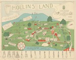
Designed and drawn by Gertrud R. Rath, Class of 1922.
"Frieze of the centuries" (based on Godey's Ladies Book fashion plates) drawn by Bell Worsham, Class of 1929,
Date: ca. 1929
Dimensions: 28.5 x 22 inches
Notes: Map features physical and architectural features of the campus. It also includes many individuals, long associated with Hollins, as well as references to traditions.
Publication Date
1929
Document Type
Map
Publisher
Hollins College
City
Roanoke, Va.
Keywords
Maps, Broadsides, Posters, Hollins College, Hollins University, Godey's Ladies Book, College Campuses, Tinker Mountain
Disciplines
Higher Education | United States History | Women's History
Recommended Citation
Rath, Gertrude R. and Worsham, Bell, "Hollins Land Map" (1929). Maps, Architectural Records, and Other Large Formats. Book 3.
http://digitalcommons.hollins.edu/maps/3
Comments
Sold "under the auspices of the General Alumnae Association." Money raised went to the Endowment Fund, necessary for Hollins College to become fully accredited.
Article "What is the Hollins Map? accompanies the map and was published in the Hollins Alumnae Quarterly (January 1931): 13-14.