
Title
Preview
Creation Date
1929
Description
-
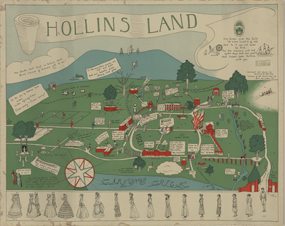
Designed and drawn by Gertrud R. Rath, Class of 1922.
-
"Frieze of the centuries" (based on Godey's Ladies Book fashion plates) drawn by Bell Worsham, Class of 1929,
-
Date: ca. 1929
-
Dimensions: 28.5 x 22 inches
-
Notes: Map features physical and architectural features of the campus. It also includes many individuals, long associated with Hollins, as well as references to traditions.
-
Sold "under the auspices of the General Alumnae Association." Money raised went to the Endowment Fund, necessary for Hollins College to become fully accredited.
-
Article "What is the Hollins Map? accompanies the map and was published in the Hollins Alumnae Quarterly (January 1931): 13-14.
Recommended Citation
Rath, Gertrude R. and Worsham, Bell, "Hollins Land Map" (1929). Maps, Architectural Records, and Other Large Formats. Book 3. http://digitalcommons.hollins.edu/maps/3
What is the Hollins Map?
Keywords
Maps, Broadsides, Posters, Hollins College, Hollins University, Godey's Ladies Book, College Campuses, Tinker Mountain