
Preview
Creation Date
10-28-1930
Description
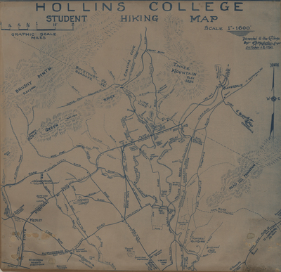
C. B. Malcolm, of Roanoke, Virginia, was a Virginia Certified Engineer.
Blue print on linen.
Dimensions: 27 1/2 x 25 1/2 inches
Notes: Map shows Roanoke County and Botetourt County lines and includes physical features such as mountains (Brushy, Green, Read, Tinker) and water ways (Peters Creek, Tinker Creek, Carvins Creek, Lick Run, Carvins Cove, Swartz Falls). Map also shows area land marks such as schools, churches, golf courses, the airport, neighborhoods (i.e. Kingston Colored Settlement) and "Mill with overshot wheel."
Recommended Citation
Hollins College Student Hiking Map, created by C. B. Malcolm, 1930.
Keywords
Maps, Hiking, Roanoke County (Va.), Botetourt County (Va.), Mountains, College Students, Outdoor Recreation, Hollins College